
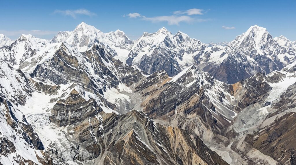
Featured Snippet Answer: How Mountains Are Formed depends on geological forces that reshape Earth’s crust over millions of years. Mountains develop when tectonic plates collide, rocks fold under pressure, crustal blocks move along faults, magma builds volcanic landforms, or underground forces push rock layers upward. Weathering and erosion then shape their height and appearance.
Introduction: The Incredible Story Behind Earth’s Mountains
Mountains are among the most impressive features on Earth. From the snow-covered peaks of the Himalayas to the volcanic slopes of Mount Fuji, these enormous landforms reveal the extraordinary power of our planet’s internal forces. Although mountains appear permanent, they are constantly changing through geological activity, weathering, and erosion.
Understanding How Mountains Are Formed helps explain why some mountain ranges contain towering, jagged peaks while others feature rounded summits, steep cliffs, or volcanic cones.
Most mountains develop through tectonic plate movement, crustal deformation, volcanic activity, and uplift. These processes can operate over millions of years, although earthquakes and volcanic eruptions sometimes change the landscape much more quickly.
In this guide, you will discover the geological forces behind mountain formation, the major types of mountains, the differences between their formation processes, and the fascinating history of famous mountain ranges around the world.
What Causes Mountains to Form on Earth?
Mountains form when geological forces push, fold, fracture, or build up Earth’s crust. The most important mechanisms include tectonic plate collisions, movement along faults, volcanic eruptions, and the upward movement of rock layers.
The Geological Forces That Shape Earth’s Surface
Earth’s outermost solid layer, the crust, forms part of a larger rigid shell called the lithosphere. The lithosphere is divided into tectonic plates that move slowly over the hotter, weaker material beneath them.
Heat escaping from Earth’s interior helps drive mantle circulation, while gravity, sinking plates, and forces associated with spreading ridges also contribute to plate movement.
These processes influence the shape of continents and ocean basins. When tectonic forces compress, stretch, or lift the crust, they can produce mountains and elevated landscapes.
Four important geological processes contribute to mountain formation:
- Compression: Pushes rocks together, causing folding, thickening, and uplift.
- Faulting: Breaks the crust and moves rock blocks vertically or horizontally.
- Volcanism: Adds lava, ash, and other volcanic material to the surface.
- Uplift: Raises sections of Earth’s crust through tectonic forces or changes in the underlying rock structure.
Erosion also plays a major role. It does not usually build mountains directly, but it carves valleys, exposes rock layers, and influences the height and shape of peaks.
How Earth’s Crust Deformation Creates Mountains
Earth’s crust can change shape when subjected to long-lasting pressure, pulling forces, or movement along fractures. Geologists call these changes crustal deformation.
When rocks experience compression, they may bend rather than break, creating folds. If the pressure exceeds their strength, the rocks may fracture and move along faults.
Crustal deformation produces several mountain-building features:
- Folded rock layers that form ridges and peaks.
- Fault-block mountains created by the displacement of large rock sections.
- Uplifted plateaus and mountain massifs.
- Steep escarpments where elevated land meets lower terrain.
The type of rock, its temperature, its depth, and the speed at which forces act determine whether it bends, fractures, or deforms in more complex ways.
How the Mountain Building Process Begins
Mountain building, also known as orogenesis, generally develops through several overlapping stages.
- Tectonic forces act on the crust. Plates converge, separate, or move along faults.
- Rocks deform or magma rises. The crust folds, fractures, thickens, or accumulates volcanic material.
- The landscape gains elevation. Uplift and repeated volcanic eruptions create mountain relief.
- Surface processes reshape the land. Rivers, glaciers, wind, and temperature changes wear down exposed rock.
Not every mountain follows this exact sequence. Volcanic mountains, for example, may grow through repeated eruptions without continental collision. The process depends on the geological setting.
How Do Tectonic Plates Create Mountains?
Tectonic plate movement is one of the most important explanations for how mountains are formed. Because Earth’s plates interact in different ways, they create several distinct mountain-building environments.
Understanding Tectonic Plate Movement
Tectonic plates move at rates commonly measured in millimeters or centimeters per year. Although this movement seems slow, it produces enormous geological changes over millions of years.
There are three main types of plate boundaries:
- Convergent boundaries: Plates move toward one another.
- Divergent boundaries: Plates move apart.
- Transform boundaries: Plates slide past each other.
Convergent boundaries are especially important for mountain formation because they can compress the crust, create volcanic arcs, and raise large mountain ranges. Divergent boundaries can also produce elevated fault-block terrain, particularly along continental rifts.
Transform boundaries are more commonly associated with earthquakes and lateral displacement, although local uplift can occur where faults bend or compress the crust.
What Happens at Convergent Plate Boundaries?
At a convergent plate boundary, two tectonic plates move toward one another. The outcome depends on whether the plates carry oceanic crust, continental crust, or a combination of both.
When two continental plates collide, neither plate easily sinks into the mantle because continental crust is relatively buoyant. The crust may become compressed, folded, thickened, and uplifted, producing extensive mountain systems.
The Himalayas are a famous example of mountains created by continental collision.
When an oceanic plate meets a continental plate, the denser oceanic plate commonly descends beneath the continental plate. This process, called subduction, can generate magma and produce volcanic mountain chains.
The Andes in South America illustrate this process.
When two oceanic plates converge, one plate may sink beneath the other, forming a volcanic island arc. Over time, repeated eruptions can build volcanic islands and mountainous terrain.
How Divergent Plate Boundaries Shape Elevated Land
At divergent boundaries, tectonic plates move apart. In continental regions, this stretching can thin and fracture the crust.
Large blocks of crust may move downward along normal faults, creating rift valleys. Neighboring blocks may remain elevated or rise relative to the surrounding land, producing fault-block mountains and steep mountain fronts.
The East African Rift contains a range of elevated landscapes, volcanic peaks, and fault-related landforms associated with continental extension.
Divergent boundaries demonstrate that mountains do not form only when plates collide. In some geological settings, stretching and faulting also create substantial relief.
What Are the Main Types of Mountains?
Mountains are classified according to their geological origins and structural features. Four widely recognized categories are fold mountains, fault-block mountains, volcanic mountains, and dome mountains.
How Fold Mountains and Fault-Block Mountains Form
Fold mountains develop when compression bends and deforms layers of rock. During continental collision, enormous sections of the crust may be shortened and thickened, causing rock layers to fold and the land to rise.
The Himalayas and Alps are prominent examples of mountain systems shaped substantially by folding and continental collision.
Fault-block mountains form when large sections of Earth’s crust move along faults. Some blocks rise relative to neighboring blocks, while others sink, producing elevated ranges, valleys, and steep escarpments.
The Sierra Nevada in the western United States is a well-known example of a mountain range with important fault-block characteristics, although its geological history also includes ancient magmatism and other tectonic processes.
The main difference is that fold mountains develop primarily through bending and compression, whereas fault-block mountains are strongly associated with displacement along fractures.
How Are Volcanic Mountains Formed?
Volcanic mountains form when magma reaches Earth’s surface and erupts as lava, ash, and other volcanic material. Repeated eruptions can gradually build a mountain around a volcanic vent.
The shape of a volcanic mountain depends on the type of magma, the nature of its eruptions, and the materials deposited.
Common volcanic landforms include:
- Composite volcanoes: Often steep-sided, with alternating layers of lava and fragmented volcanic material.
- Shield volcanoes: Broad structures formed largely by repeated flows of relatively fluid lava.
- Cinder cones: Smaller, steep-sided cones built mainly from loose volcanic fragments.
Mount Fuji in Japan is a classic example of a volcanic mountain. Mount Kilimanjaro in Tanzania is another famous volcanic mountain system.
Volcanic mountains can grow relatively quickly during periods of intense eruption, but many develop through repeated activity over thousands to hundreds of thousands of years or longer.
What Are the Different Types of Mountain Landforms?
Fold mountains: Created mainly by compression and folding. Examples include the Himalayas and Alps.
Fault-block mountains: Formed through movement along faults that elevates or lowers crustal blocks. The Sierra Nevada is an example.
Volcanic mountains: Built by accumulated lava and other volcanic material. Examples include Mount Fuji and Mount Kilimanjaro.
Dome mountains: Develop when broad areas of rock are uplifted into a dome-like shape. Later erosion may expose the underlying structure. The Black Hills of South Dakota are a classic example of an uplifted dome-shaped mountain region, although their present landscape reflects extensive erosion and complex geological history.
Some mountain ranges combine several formation processes. These categories are useful for understanding their dominant origins, rather than suggesting that every mountain fits into one completely separate group.
How Are Different Mountain Formation Processes Compared?
The different ways mountains form explain why their structures, rock types, and landscapes vary so widely.
How Are Fold Mountains Different From Fault-Block Mountains?
Fold mountains primarily develop when compression bends and shortens rock layers. Fault-block mountains form when sections of crust move along fractures.
Folded ranges commonly contain complex layers of sedimentary and metamorphic rocks. Fault-block ranges may feature steep escarpments, tilted rock layers, and broad elevated blocks.
Both types can rise through tectonic uplift, but their structural characteristics reveal different deformation processes.
How Do Volcanic Mountains Differ From Fold Mountains?
Volcanic mountains are constructed from material erupted from Earth’s interior. Fold mountains develop mainly when tectonic forces compress and deform existing rock layers.
Volcanic mountains may contain lava flows, ash deposits, and volcanic rock. Fold mountains often display folded sedimentary layers, metamorphic rocks, and evidence of crustal shortening.
Their hazards also differ. Active volcanic mountains may experience eruptions and volcanic gas emissions, while tectonically active fold mountains can experience earthquakes, landslides, and rapid changes in steep terrain. Some mountain regions experience both volcanic and seismic hazards.
Which Geological Processes Create the Tallest Mountains?
No single process always creates the tallest mountains. Elevation depends on crustal thickness, tectonic uplift, the strength and density of rocks, erosion, climate, and the duration of mountain building.
Continental collision has created some of Earth’s highest peaks. Mount Everest, the highest mountain above sea level, lies in the Himalayas, where the Indian Plate continues to converge with the Eurasian Plate.
Volcanism can also produce enormous mountains. Mauna Kea in Hawaii, for example, rises more than 10,000 meters from its submarine base to its summit, although much of that height lies beneath the ocean.
These examples show why mountain height must be evaluated carefully. A mountain’s height above sea level and its total height from base to summit are different measurements.
Mountain Types Compared: Formation Process and Examples
| Mountain type | Formation process | Example |
|---|---|---|
| Fold | Compression, folding, and crustal thickening | Himalayas |
| Fault-block | Displacement of crustal blocks along faults | Sierra Nevada |
| Volcanic | Accumulation of lava and volcanic material | Mount Fuji |
| Dome | Broad uplift of rock layers followed by erosion | Black Hills |
This comparison provides a quick way to identify the major mountain types and understand the geological forces responsible for their formation.
Why Do Continental Plates Collide and Form Mountain Ranges?
Continental plates collide because tectonic plates are continually moving under the influence of forces within the Earth system, including slab pull, ridge-related gravitational forces, and mantle dynamics.
When two continental plates converge, the resulting compression can build extensive mountain ranges.
What Happens During Continental Plate Collision?
Continental crust is generally less dense than the mantle and is relatively buoyant compared with oceanic lithosphere. When two continents meet, neither can easily descend completely beneath the other.
Instead, the crust may shorten horizontally and thicken vertically. Rock layers fold, faults develop, and large sections of the crust can be pushed over neighboring sections along major thrust faults.
These processes create elevated mountain belts and high plateaus. The collision between India and Eurasia is the principal cause of the Himalayan mountain system and the uplift of the Tibetan Plateau.
Continental collisions can continue for tens of millions of years, producing complicated geological structures that change as the plates continue moving.
How Subduction Zone Formation Creates Mountains
Subduction occurs when one tectonic plate descends beneath another. It commonly develops at convergent boundaries where dense oceanic lithosphere moves into the mantle.
As the descending plate releases water and other fluids into the overlying mantle, these fluids help promote melting. Magma can then rise and feed volcanoes.
Repeated eruptions and the intrusion of magma into the crust can create volcanic mountain chains. Compression and deformation near the plate boundary can also raise and fold surrounding rock.
The Andes provide a major example of mountain building associated with the subduction of the Nazca Plate beneath the South American Plate.
Subduction does not always produce the same landscape. The angle of the descending plate, the composition of the crust, and the local tectonic setting influence whether the region develops volcanoes, folded mountains, a trench, or other geological features.
How Individual Mountains Become Mountain Ranges
A mountain range is usually the result of regional geological forces affecting a broad area rather than a single isolated event.
When tectonic compression acts across a large region, many folds and faults can develop. Different sections of the crust rise at different rates, creating interconnected peaks, ridges, valleys, and plateaus.
Volcanic regions can also contain multiple mountains formed by related magma systems and repeated eruptions.
Over time, erosion separates individual peaks and carves valleys between them. This combination of regional uplift and surface erosion creates the complex landscapes associated with major mountain ranges.
How Long Does Mountain Formation Take?
Mountain formation takes different amounts of time depending on the geological process, the rate of tectonic movement, the type of rock, and the surrounding environment.
Many major mountain ranges develop over millions to tens of millions of years, although some volcanic structures can grow substantially during shorter periods of repeated eruptions.
How Long Does It Take for Mountains to Form?
There is no universal timeline for mountain formation.
Some volcanic cones can develop during a single eruption or a sequence of eruptions over a relatively short period. Large volcanic mountains, however, may require many episodes of activity.
Fold and fault-block mountain systems generally develop through repeated tectonic deformation over much longer periods.
The Himalayas, for instance, began rising following the collision of the Indian and Eurasian continental plates around 50 million years ago, although the exact timing of initial collision and the development of individual Himalayan structures remains an area of geological research.
The important point is that mountain building usually involves multiple events rather than one continuous, uninterrupted process.
Can Mountains Grow Taller Over Time?
Yes. Mountains can become taller when tectonic uplift raises their rocks or when volcanic eruptions add new material.
However, mountains are also worn down by erosion. Rivers cut valleys, glaciers remove rock, and landslides transport material downslope.
The balance between uplift and erosion helps determine whether a mountain’s elevation increases, decreases, or remains relatively stable over a particular period.
Even when the overall mountain range is rising, individual peaks may lose height as erosion removes their upper rock layers.
Earthquakes can cause sudden local changes in elevation, but these changes are part of a larger geological history.
Why Do Mountains Have Different Shapes?
Mountain shapes reflect a combination of geology, climate, uplift, and erosion.
Rock type: Hard, resistant rocks may form prominent peaks, while weaker rocks erode more quickly.
Climate: Heavy rainfall can accelerate river erosion, while freeze-thaw cycles can break exposed rocks apart.
Glaciers: Moving ice can carve deep valleys, steep headwalls, and sharp ridges.
Tectonic activity: Active uplift can create steep terrain and sustain high relief.
Time: Older mountain landscapes often show extensive erosion, although their appearance depends on rock resistance, climate, and later tectonic activity.
These influences explain why two mountain ranges formed by broadly similar processes can develop very different appearances.
Mountain Formation Timeline
The following sequence illustrates a common pathway for tectonic mountain building. The stages overlap, and volcanic or fault-block mountains may follow different sequences.
Stage 1 — Tectonic forces begin: Plates converge, crust stretches, or stresses accumulate along faults.
Stage 2 — Rocks deform: Layers fold, faults move, crust thickens, or magma begins accumulating.
Stage 3 — Mountain relief develops: Uplift and repeated geological activity produce elevated terrain.
Stage 4 — The landscape is reshaped: Rivers, glaciers, landslides, and weathering carve valleys and alter the peaks.
Mountain formation is therefore not a simple four-step process with fixed durations. Some stages occur simultaneously, and tectonic activity may continue while erosion reshapes the landscape.
How Were the Himalayas Formed?
The Himalayas are among the world’s most impressive examples of mountain building through continental collision. Their formation illustrates how the movement of tectonic plates can transform an entire region.
How the Indian and Eurasian Plates Collided
The Indian Plate moved northward toward the Eurasian Plate over geological time. When the intervening oceanic crust was consumed by subduction, the continental landmasses eventually collided.
Because continental crust is relatively buoyant, the collision caused extensive compression, folding, thrust faulting, and crustal thickening.
These processes raised the Himalayan mountain belt and contributed to the uplift of the Tibetan Plateau.
The collision began roughly 50 million years ago, although scientists continue to investigate its precise timing, the earlier stages of convergence, and the sequence of deformation across the region.
The Himalayas remain an active tectonic system rather than a finished geological structure.
Why the Himalayas Continue to Change
The Indian Plate continues to move toward Eurasia, sustaining tectonic deformation across the region. This ongoing movement contributes to earthquakes and continuing uplift in parts of the mountain system.
At the same time, weathering and erosion reshape the peaks. Rivers transport sediment from steep valleys, while glaciers carve high-altitude landscapes and move rock debris.
Landslides can rapidly change slopes, especially during intense rainfall or earthquakes.
The Himalayas therefore reflect a continuing balance between tectonic forces that raise the land and surface processes that wear it down.
How the Himalayas Compare With Other Mountain Ranges
The Himalayas: Formed mainly through the collision of the Indian and Eurasian continental plates. They contain Earth’s highest summit above sea level, Mount Everest.
The Andes: Developed along the western edge of South America through subduction of oceanic lithosphere beneath the continent, with volcanism, compression, and uplift playing major roles.
The Alps: Formed through complex convergence and collision involving the African and Eurasian plates and intervening continental fragments. Folding, thrusting, and crustal thickening helped create the range.
All three are major tectonic mountain systems, but their geological histories differ. The Himalayas are a classic example of continental collision, the Andes illustrate an active continental margin with subduction-related volcanism, and the Alps reflect a complex history of ocean closure and continental convergence.
Can Earthquakes Create New Mountains?
Earthquakes can change the shape of Earth’s surface by moving rock along faults. Some earthquakes cause local uplift, while others produce subsidence or horizontal displacement.
However, a sudden change in elevation is not the same as building an entire mountain range.
How Earthquakes Cause Sudden Ground Uplift
When stress accumulates in Earth’s crust and a fault slips, the surrounding rocks may move vertically as well as horizontally.
In compressional environments, thrust faults can push rock upward over neighboring rock. This movement may raise part of a mountain slope or alter the elevation of a ridge.
In other settings, an earthquake can lower the ground or shift it sideways.
These changes may range from small movements to several meters of displacement in particularly large events. The exact result depends on the fault’s geometry, the amount of slip, and the surrounding geology.
Earthquakes can therefore contribute to mountain growth by producing uplift, especially in active mountain belts.
Can One Earthquake Create an Entire Mountain?
Usually, no. A single earthquake may raise a section of land, create a fault scarp, or change a ridge’s elevation, but an entire mountain typically reflects a much longer geological history.
Mountain building commonly requires repeated fault movements, sustained tectonic uplift, volcanic activity, or a combination of processes.
A newly exposed ridge after an earthquake may look dramatic, but it is generally a small part of a larger tectonic system.
The distinction is important: earthquakes can produce rapid local changes, while major mountain ranges usually develop through geological processes operating over thousands to millions of years.
How Earthquakes Reveal Active Mountain Formation
Scientists study earthquakes to understand where and how Earth’s crust is deforming.
They use several methods:
- Seismometers: Record seismic waves and help locate earthquakes.
- GPS measurements: Track small changes in the positions of points on Earth’s surface.
- Satellite radar: Detects ground deformation over large areas.
- Geological mapping: Identifies faults, folded rocks, and evidence of earlier uplift.
- Field surveys: Measure displaced landforms and document changes after major earthquakes.
Together, these techniques help researchers estimate how quickly mountain regions are deforming and identify areas where tectonic forces continue to shape the landscape.
Conclusion: Understanding How Mountains Are Formed
Understanding How Mountains Are Formed reveals how dynamic our planet really is. Mountains develop through continental collisions, tectonic compression, fault movement, volcanic eruptions, and the uplift of rock layers. These processes operate at different rates and produce a remarkable variety of landscapes.
The Himalayas demonstrate the power of continental collision, the Andes reveal the influence of subduction, and Mount Fuji illustrates how repeated volcanic eruptions can build a mountain.
Yet mountain formation does not end when peaks emerge. Earthquakes, tectonic uplift, weathering, glaciers, and erosion continue to reshape them.
The next time you see a mountain range, consider the geological story hidden beneath its surface. Research a famous peak or explore a nearby mountain landscape to discover which forces created it and how it continues to change today.
Scientific Sources for Further Reading
For reliable geological information, explore these educational and scientific resources:
- U.S. Geological Survey (USGS): https://www.usgs.gov/
- National Park Service — Geology: https://www.nps.gov/subjects/geology/index.htm
- Encyclopaedia Britannica — Mountain: https://www.britannica.com/science/mountain-landform
- National Geographic Education: https://education.nationalgeographic.org/
- NASA Solar System Exploration: https://science.nasa.gov/solar-system/
Use these sources to verify geological terminology, explore tectonic processes, and learn more about specific mountain ranges.
Frequently Asked Questions About How Mountains Are Formed
Tectonic activity is the main cause of many major mountain ranges. When tectonic plates collide, rocks may fold, the crust thickens, and the land rises. Mountains can also form through faulting, volcanic eruptions, and the uplift of rock layers.
No. Although plate collisions create many major mountain ranges, volcanic eruptions can build volcanic mountains, and movement along faults can produce fault-block mountains. Broad uplift can also create dome-shaped mountain structures.
Yes. Weathering, rivers, glaciers, landslides, and other erosional processes gradually remove rock from mountains. If uplift slows or stops, erosion can substantially lower a mountain range over millions of years. Some mountain regions may also be buried by sediment or altered by later tectonic events.
Yes. Mountains and mountain-like landforms exist on other planets and moons. Olympus Mons on Mars, for example, is an enormous shield volcano formed by volcanic activity. Mountains on other worlds develop under different gravitational, tectonic, volcanic, and impact-related conditions.

“Hi, I am Umer Hasib. I am a passionate blogger and content creator who loves exploring human psychology, social behaviors, and personal growth. Welcome to my inner space!”
Emily Carter
I never realized that mountains could take millions of years to form! The explanation of tectonic plate collisions and the Himalayas was fascinating. Nature is truly amazing!
Thank you, Emily! 😊 Earth’s geological processes are incredible, and the Himalayas are a perfect example of how our planet changes over millions of years. Keep exploring and learning!
James Anderson
This article explained mountain formation in a very simple and interesting way. I especially enjoyed learning the differences between fold mountains, fault-block mountains, and volcanic mountains.
We’re glad you enjoyed it, James! 🌍 Each mountain type has a unique geological story. Thanks for reading and sharing your thoughts!